


Описание Map Pad GPS Land Surveys & Measurements
Use MapPad to calculate areas, perimeters and distances and save, export or share your measurements.
MapPad is providing multi-purpose mapping solution allowing location capture and determines distance and area for the shapes drawn on the map or captured using real-time GPS tracking.
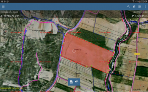
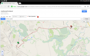
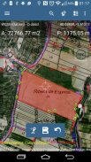
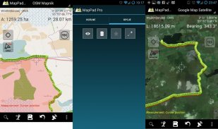
Calculate area of the field or a walk distance instantly using Google or Bing Map Satellite view. Save petrol and time and capture features with few clicks on the map.
With MapPad you can capture, manage and share your data easily.
MapPad is a very useful tool for anyone involved in forestry, agriculture, engineering and real estate management.
Please visit our website to find out how to prepare offline map and get more information about this product.
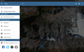
Selected features:
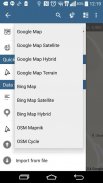
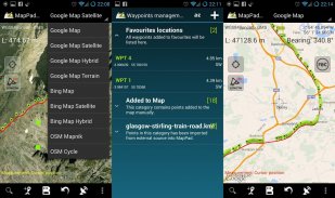
- Base maps: Google Maps, Open Street Map, Bing Maps
- Google Maps Overlays (Custom WMS or ArcGIS Server Tiled service), some layers like US Topographic map have been predefined.
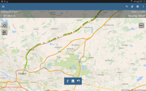
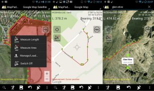
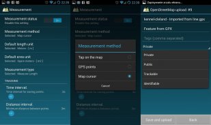
- Very accurate measurement of areas and distances.
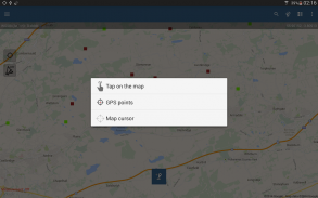
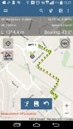
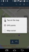
- 3 methods of measurement are supported (Tap on the map, GPS location, Map cursor location).
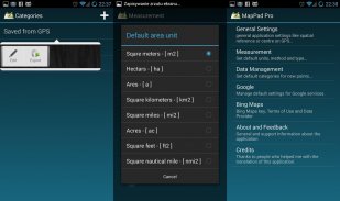
- Support for number of metric and imperial units.
- Support for several global and local coordinate systems, if you require support for any other spatial reference please get in touch.
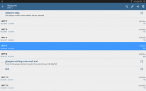
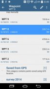
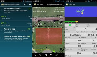
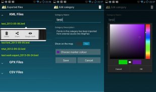
- Possibility to capture waypoints and group them in categories.
- Possibility to add or edit title and description for each recorded measurement and waypoint.
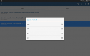
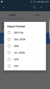
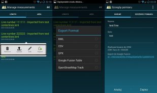
- Export single or multiple measurements or waypoints to SHP File, Geojson, ArcGIS Json, KML, GPX, CSV and DXF to SD Card or cloud services las well as direct export to Open Street Map.
- Share single waypoint location directly by SMS, E-mail or other ways.
- Elevation profile available for measurements done by GPS.
- Import of KML and GPX files to the application.
- GPS status and satellites status.
- Address, location search.
- Quick open exported KML files in Google Earth
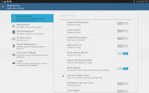
- Ability to set default measurement units, waypoints' categories colours, track recording time and distance interval, transparency of Google Maps overlays and much more...
Our users are successfully using MapPad in number of projects and applications.
Используйте MapPad для расчета площадей, периметров и расстояний, а также сохраняйте, экспортируйте или делитесь своими измерениями.
MapPad предоставляет многоцелевое картографическое решение, позволяющее захватывать местоположение и определять расстояние и площадь для фигур, нарисованных на карте или захваченных с помощью GPS-слежения в реальном времени.
Рассчитайте площадь поля или пройденное расстояние мгновенно, используя Google или Bing Map Satellite. Экономьте бензин и время и захватывайте функции с помощью нескольких кликов на карте.
С MapPad вы можете легко собирать данные, управлять ими и делиться ими.
MapPad - очень полезный инструмент для всех, кто занимается лесным хозяйством, сельским хозяйством, проектированием и управлением недвижимостью.
Пожалуйста, посетите наш веб-сайт, чтобы узнать, как подготовить автономную карту и получить больше информации об этом продукте.
Избранные особенности:
- Базовые карты: Google Maps, Open Street Map, Bing Maps
- Google Maps Overlays (пользовательский сервис WMS или ArcGIS Server Tiled), некоторые слои, такие как топографическая карта США, были предопределены.
- Очень точное измерение площадей и расстояний.
- Поддерживаются 3 метода измерения (нажмите на карту, местоположение GPS, местоположение курсора на карте).
- Поддержка количества метрических и имперских единиц.
- Поддержка нескольких глобальных и локальных систем координат, если вам требуется поддержка любой другой пространственной привязки, пожалуйста, свяжитесь с нами.
- Возможность фиксировать путевые точки и группировать их по категориям.
- Возможность добавлять или редактировать заголовок и описание для каждого записанного измерения и путевой точки.
- Экспорт одного или нескольких измерений или путевых точек в файл SHP, Geojson, ArcGIS Json, KML, GPX, CSV и DXF на SD-карту или в облачные сервисы, а также прямой экспорт в Open Street Map.
- Поделитесь одним местоположением путевой точки напрямую с помощью SMS, электронной почты или другими способами.
- Профиль высоты доступен для измерений, выполненных с помощью GPS.
- Импорт файлов KML и GPX в приложение.
- GPS-статус и статус спутников.
- Адрес, местоположение, поиск.
- Быстрое открытие экспортированных файлов KML в Google Earth
- Возможность установки единиц измерения по умолчанию, цветов категорий путевых точек, времени записи трека и интервала расстояний, прозрачности наложений Google Maps и многого другого ...
Наши пользователи успешно используют MapPad в ряде проектов и приложений.
Map Pad GPS Land Surveys & Measurements - Версия 7.5.0
(19-05-2019)
Map Pad GPS Land Surveys & Measurements - Информация об APK
Версия APK: 7.5.0Пакет: com.osedok.mappadПриложения в этой категории
Вам также могут понравиться...


